
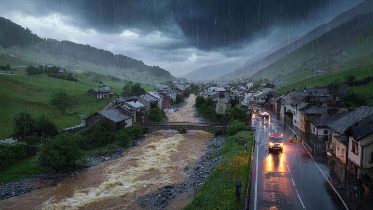
Maria Gonzalez thought she knew her neighborhood creek well. For fifteen years, she’d walked her dog along the gentle stream that meandered behind her Austrian village. On quiet summer evenings, her children would skip stones across its shallow waters.
Then came that Tuesday in August. Within twenty minutes, what had been a babbling brook transformed into a roaring monster that swept away two cars and flooded her basement with three feet of murky water. “It happened so fast,” Maria recalls. “One moment we were having coffee, the next we were running for our lives.”
Maria’s story isn’t unique. Across Europe and beyond, communities are discovering that the rainfall change we’re experiencing goes far deeper than just “more rain.” It’s fundamentally altering how storms behave, creating flood risks that catch even experienced residents off guard.
The Hidden Truth About Modern Rainfall
Scientists have been warning us about heavier rainfall for decades, but new research reveals something more troubling. Austrian researchers analyzing over a century of weather data discovered that not all rain is changing equally – and this difference is literally a matter of life and death.
The study, published in the prestigious journal Nature, separated rainfall into two distinct categories: short, explosive bursts lasting just hours, and longer, gentler multi-day events. The results were eye-opening.
“Short, sharp bursts of rain have intensified by around 15% over the past 40 years in parts of Austria, while long-duration rainfall shows a far weaker trend,” explains Dr. Sarah Chen, a climate hydrologist not involved in the study.
This pattern emerged consistently across different regions, from valleys to mountainsides, suggesting that large-scale atmospheric changes are driving this shift rather than local weather quirks.
Think about it this way: your grandfather’s rainstorms might have delivered the same total amount of water over three days. Today’s storms dump that same water in three hours. Your drainage systems, built decades ago, simply weren’t designed for this new reality.
What’s Really Happening to Our Weather
The science behind this rainfall change is surprisingly straightforward, but its implications are profound. Here’s what’s driving these dramatic shifts:
- Warmer air holds more moisture – For every degree of warming, the atmosphere can store about 7% more water vapor
- Higher energy levels – Warmer temperatures inject more energy into storm systems
- Faster storm development – These energized systems can intensify much more rapidly
- Enhanced convection – Hot air rises faster, feeding towering thunderclouds
The most dangerous aspect is how quickly these storms can explode into life. Meteorologist James Rodriguez notes, “We’re seeing storms that go from barely noticeable to dangerous in under an hour. Traditional warning systems struggle with that timeline.”
Consider this comparison of rainfall patterns:
| Storm Type | Traditional Pattern | Modern Pattern | Flood Risk |
|---|---|---|---|
| Short Duration | 10-20mm/hour | 30-50mm/hour | Very High |
| Medium Duration | 5-10mm/hour | 15-25mm/hour | High |
| Long Duration | 2-5mm/hour | 3-7mm/hour | Moderate |
The physics tells a clear story. Warmer air is more buoyant, rising faster and feeding those towering storm clouds that unleash torrential downpours. Instead of a gentle afternoon shower, communities face 40 millimeters of rain in less than an hour.
Urban areas face particular challenges because concrete and asphalt can’t absorb water like natural soil. When that intensity hits pavement, every drop becomes runoff, overwhelming storm drains designed for gentler rainfall patterns.
Who’s Really at Risk From These Changes
This rainfall change isn’t affecting everyone equally. Some communities are finding themselves on the front lines of a weather pattern they never expected to face.
Mountain valleys and urban areas with older infrastructure bear the greatest risk. Small streams that families have lived beside for generations can become deadly torrents within minutes. Cities with combined sewer systems – where stormwater and sewage share the same pipes – face particularly nasty consequences when intense downpours overwhelm capacity.
“Many communities are prepared for ‘a lot of rain,’ but far fewer are ready for ‘a lot of rain all at once,'” explains flood management expert Dr. Lisa Park.
The economic impact is staggering. Insurance claims for flash flood damage have increased by over 200% in some European regions over the past decade. But the human cost tells the real story – families like Maria’s who lose irreplaceable memories and face months of repairs.
Farmers are struggling too. While crops need water, the intense bursts of modern rainfall often cause more harm than good. Seeds get washed away, topsoil erodes, and root systems can’t cope with the feast-or-famine pattern of modern precipitation.
Emergency services are adapting their approaches. Traditional flood preparation focused on rising river levels over days. Now they’re training for scenarios where normal conditions turn dangerous in under an hour.
The psychological impact shouldn’t be underestimated either. Residents in previously safe areas report feeling anxious during any significant weather event. Parents keep children indoors during summer thunderstorms that their own parents would have considered harmless.
Looking ahead, climate models suggest this trend will continue. Dr. Martinez, a atmospheric physicist, warns, “We’re still in the early stages of this transition. The rainfall change we’re seeing now is likely just the beginning.”
Some communities are already adapting. Rotterdam has built underground water storage areas that can hold millions of gallons during intense storms. Australian cities are installing permeable concrete that allows water to soak through rather than run off.
But for most places, the infrastructure changes needed require years of planning and massive investment. In the meantime, residents like Maria are learning to read weather patterns with new urgency, knowing that the gentle creek behind their home could transform into something unrecognizable with frightening speed.
FAQs
How is climate change affecting rainfall patterns differently than expected?
While scientists predicted heavier rainfall, new research shows that short, intense bursts are increasing much more dramatically than longer, gentler rains – creating unique flood risks.
Why are flash floods becoming more common even in areas that never had them before?
Warmer air holds more moisture and has more energy, causing storms to develop faster and dump larger amounts of water in shorter time periods than drainage systems were designed to handle.
Can weather forecasts predict these sudden intense storms?
Traditional forecasting struggles with storms that intensify rapidly, though meteorologists are developing new techniques to provide earlier warnings for these explosive weather events.
What can communities do to prepare for this new rainfall pattern?
Cities need to upgrade drainage infrastructure, create water storage areas, and develop rapid response systems, while residents should learn to recognize warning signs and have evacuation plans ready.
Are some regions more affected by this rainfall change than others?
Mountain valleys, urban areas with older infrastructure, and regions with combined sewer systems face the highest risks, though the pattern is appearing globally as temperatures rise.
How much more intense have these short bursts of rain become?
Research in Austria found that brief, intense rainfall has intensified by around 15% over the past 40 years, while longer duration rains show much smaller increases.